Using Virtual and Augmented Reality in Planetary Imaging and Mapping
Being a planetary scientist is not easy. Huge amounts of data are acquired by a wide range of instruments onboard spacecrafts and rovers, and still you can’t directly explore the places you are studying and experience real sizes and distances.
Fortunately, in recent years, Virtual Reality (VR) and Augmented Reality (AR) capabilities have improved greatly, providing scientists with new ways and means to visualise their data. An example of this is provided by the work of Stéphane Le Mouélic (Laboratoire de Planétologie et Géodynamique of Nantes, France) and his colleagues presented at EPSC2020.
“The aim of our study is to allow the user to fly over or walk on planetary surfaces using VR techniques,” says Stéphane. “The instruments provide high resolution imagery (up to 25 cm/pixel and 40 cm/pixel from orbit on Mars and the Moon), imaging spectroscopy (the analysis of the reflected light at different colours, which gives insights into the composition of the surface), and altimetry using either LIDAR or stereoscopic techniques. Onboard rovers and cameras observing the landscape elements from different angles also allow the 3D reconstruction of local geological features of interest using advanced photogrammetric techniques. Our job is to investigate how this orbital and in situ imagery can be merged into virtual environments.”
Using a VR headset to explore an immersive scene or to manipulate a 3D rendition of a geological outcrop, scientists can have a better understanding of its configuration and evolution – a story often related to the processes of formation (sedimentary or volcanic origin for example). It also allows a better understanding of the real sizes and distances (something difficult to evaluate in desert terrain with no human artifacts to provide a reference) and, overall, it allows the exploration of inaccessible remote places.
VR models can be rendered by different means, from web-based platforms for simple visualisations to game engines for more sophisticated analysis. Geological measurement tools such as a compass, telemeter, clinometer can be reproduced in VR to quantitatively investigate geological landforms.
The project is supported through PlanMap, a Horizon 2020 European project with a consortium of partners from Italy, France, Germany and UK. PlanMap is focused on geological mapping and 3D geo-modelling in the Solar System and produces a wide variety of cartographic products for Mercury, the Moon and Mars. The Laboratory of Planetology and Geodynamics in France, who contributes to this research project, is involved in many space missions on various planetary bodies (Mercury, Mars, Titan, icy satellites…) and has been carrying out several VR projects since 2013. Together with VR2Planets, a startup focusing on VR applications for geosciences and education, they worked within PlanMap to develop geological measurements tools for the Kimberley area on Mars and provide virtual rendering for geological mapping purposes.
For more information about the work, you can have a look at Stéphane’s poster presentation, Using Virtual and Augmented Reality in Planetary Imaging and Mapping – a Case Study, during EPSC2020 (https://meetingorganizer.copernicus.org/EPSC2020/EPSC2020-589.html), or visit the official website of the project: http://Planmap.eu
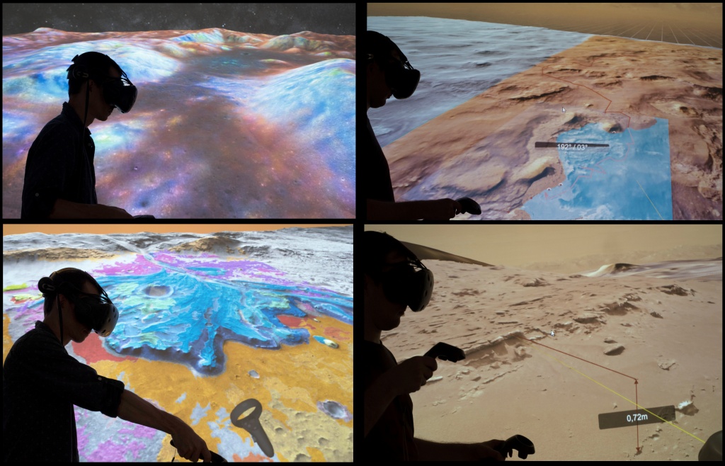
The immersion offered by Virtual Reality allows visualizing and manipulating various cartographic products; it offers a new potential for “geologic field trips” on planetary surfaces. Credits: LPG/CNRS/PlanMap/VR2Planets
Adriana Postiglione, EPSC 2020 Press Officer
