Virtual hiking Map for Jezero Crater, the Mars 2020 Perseverance Rover Landing Site
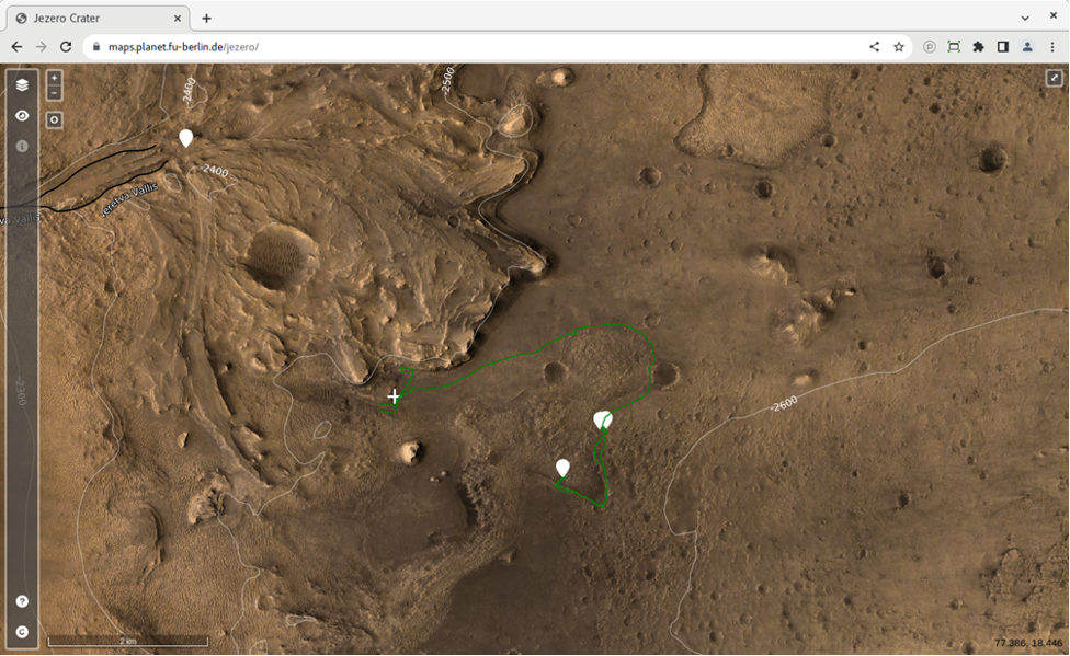
Prospective Mars explorers can now take a hike around the landing site of NASA’s Mars 2020 Perseverance rover with an interactive map loaded with orbital imagery, terrain data as well as synthetic and real 3D panoramic views of Jezero crater and its surrounding area. The map, which can be accessed through a normal web browser, has been presented today at the Europlanet Science Congress (EPSC) 2022 in Granada, Spain, by Sebastian Walter of the Freie Universität Berlin.
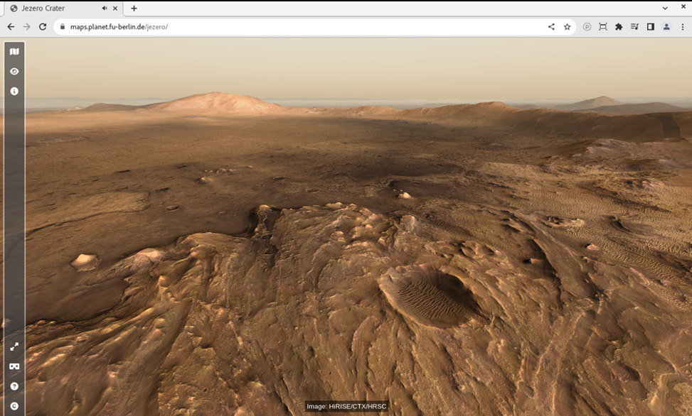
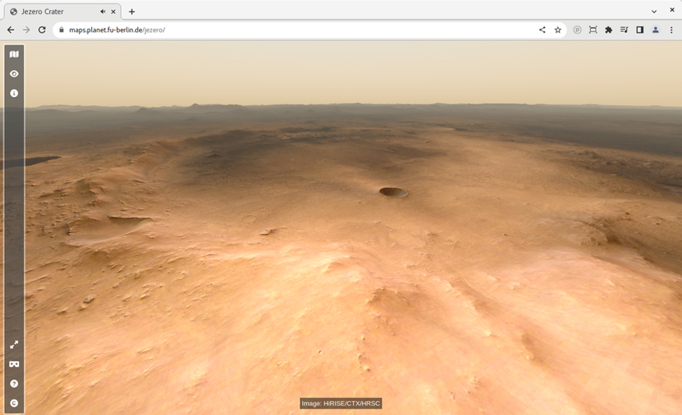
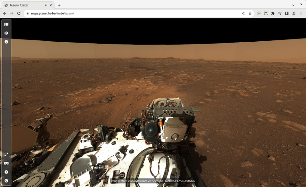
“The map is the perfect tool for planning a future visit to Mars, with an interactive interface where you can choose from different available base datasets. Some of the slopes are pretty steep, so watch out for those if you want to avoid too much oxygen consumption!” said Sebastian Walter. “To get a real feeling of what to expect on your future Mars trip, you can click on one of the waypoint marker symbols to enter either a fullscreen 3D view or, if you have a Virtual Reality setup, to enter a fully immersive environment. You can even listen to the sounds of the rover if you stand close by, but please don’t touch it – otherwise you would contaminate the probes.”
The map allows virtual hikers to zoom in and out, and pan rapidly across scenes, so that they can explore the landscape from large scales down to centimetre-detail. Some of the 360° panoramas integrated with the waypoints have been synthetically rendered from orbital image data. Others are real panoramas stitched together from a multitude of single images taken by the Mastcam-Z camera instrument onboard the Mars 2020 Rover Perseverance, which have been provided by the University of Arizona. The sounds have been recorded by the SuperCam instrument on that same rover mission.
The base layer of the map is a merged dataset derived from three different instruments currently orbiting Mars: the HRSC on Mars Express, and the Context Camera (CTX) and High Resolution Imaging Science Experiment (HiRISE) instruments on Mars Reconnaissance Orbiter (MRO). The HiRISE data has been provided by provided by the Terrain Relative Navigation (TRN) team of the Jet Propulsion Laboratory (JPL).
The Jezero map builds on the data portal of the High Resolution Stereo Camera (HRSC) instrument of ESA’s Mars Express mission, which provides tools to visualise and disseminate large amounts of Mars images and terrain data in an online environment.
“Initially we created the Jezero map as an outreach application to complement the HRSC Mapserver tool, which supports professional scientists to explore the Martian surface,” said Sebastian Walter. “But as the rover returns more and more high-resolution image data and even audio recordings, it turns out to be the perfect tool for immersive visualisation of that data in a scientific context by itself.”
Further information:
Direct link to the interactive map: https://maps.planet.fu-berlin.de/jezero
Walter, S.H.G., Gross, C., Neesemann, A., Munteanu, R., Jaumann, R., Postberg, F., and Bell, J.: An Interactive Virtual Hiking Map for Jezero Crater, the Mars 2020 Perseverance Rover Landing Site, Europlanet Science Congress 2022, Granada, Spain, 18–23 Sep 2022, EPSC2022-32, https://doi.org/10.5194/epsc2022-32, 2022.
Acknowledgements: This work is supported by the German Space Agency (DLR Bonn), grant 50 OO 2204, on behalf of the German Federal Ministry for Economic Affairs and Climate Action.
Images
Science Contacts
Sebastian Walter
Freie Universität Berlin
Planetary Sciences and Remote Sensing
sebastian.walter@fu-berlin.de
Media Contacts
EPSC2022 Press Office
+44 7756 034243
epsc-press@europlanet-society.org
Notes for Editors
About the Europlanet Science Congress (EPSC)
The Europlanet Science Congress (https://www.epsc2022.eu/) formerly the European Planetary Science Congress, is the annual meeting of the Europlanet Society. With a track record of 16 years, and regularly attracting around 1000 participants, EPSC is the largest planetary science meeting in Europe. It covers the entire range of planetary sciences with an extensive mix of talks, workshops and poster sessions, as well as providing a unique space for networking and exchanges of experiences.
Follow on Twitter via @europlanetmedia and using the hashtag #EPSC2022.
About Europlanet
Since 2005, Europlanet (www.europlanet-society.org) has provided Europe’s planetary science community with a platform to exchange ideas and personnel, share research tools, data and facilities, define key science goals for the future, and engage stakeholders, policy makers and European citizens with planetary science.
The Europlanet 2024 Research Infrastructure (RI) has received funding from the European Union’s Horizon 2020 research and innovation programme under grant agreement No 871149 to provide access to state-of-the-art research facilities and a mechanism to coordinate Europe’s planetary science community.
The Europlanet Society promotes the advancement of European planetary science and related fields for the benefit of the community and is open to individual and organisational members. The Europlanet Society is the parent organisation of the Europlanet Science Congress (EPSC).
About EANA
The European Astrobiology Network Association (http://www.eana-net.eu), joins together people interested in the origins of life and the search for extraterrestrial life in the Solar System and beyond. This interdisciplinary domain involves scientists from multiple disciplines such as chemistry, physics, biology, geology, astronomy, and human sciences.
