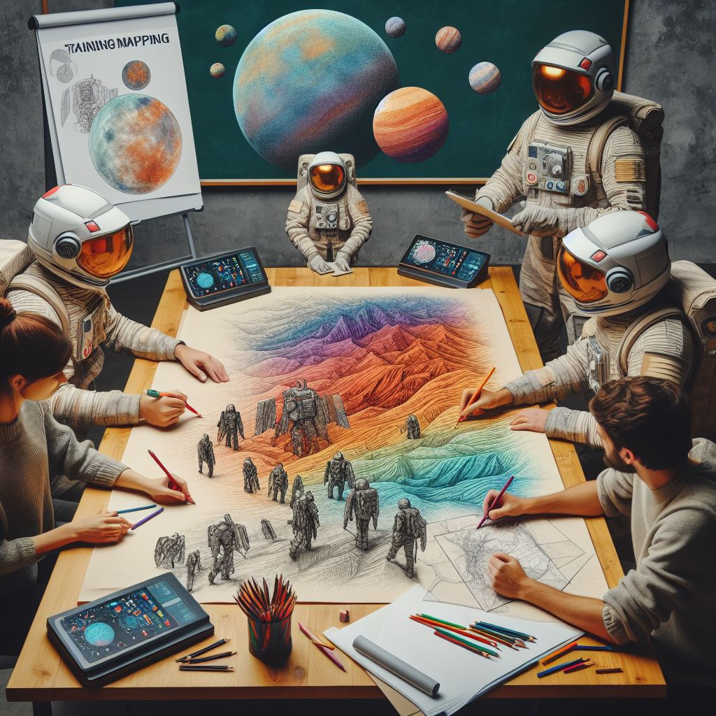
Call for Submission – Atlas of Planetary Geological Maps
The Europlanet 2024 RI GMAP infrastructure has opened a call for contributions for an Atlas of Planetary Geological Maps.
The Atlas aims to provide examples of geological maps of planets and small bodies to highlight different mapping approaches and adopted methodologies in various environments and for different purposes. This collection is thought to provide guidance and inspiration to students and scientists willing to approach geological mapping in different planetary contexts. Thus, contributions focused on specific mapping tools and workflows will be warmly welcome.
Banner and Illustration: Image Creator from Designer (Bing/DALL-E)
Given the didactic purpose of the volume, the maps can be also excerpts of already published maps, but they must be focused on definite geological environments and specifically accompanied with thoughtful explanations of the adopted work-flows and mapping tools.
The volume will have an ISBN number provided by ISPRA through the Geological Survey of Italy.
All the geological maps selected for the Atlas, and their underlying datasets, will also be included in the Europlanet-GMAP data portal, and relevant repositories for public use.
The volume will have a format of A4 cm with A3 maps. The exact number of pages for each contribution will be defined after having received the indications of interest.
As reference for the foreseen final product, you can check the ISPRA atlas “Mapping Geology in Italy”.
The received manuscripts will be revised by the editors, we do not foresee external reviews, specifically for already published maps, and map-related scientific results.
The final PDF will be openly accessible online.
Hard copies will be limited in number.
An indication of interest to submit your mapping work with a brief description of the topic should be sent to lucia.marinangeli@unich.it by Feb. 29.
Tentative Timeline:
Indication of Interest: February 29, 2024 Submission deadline: 15 May 2024 Contributions acceptance: June 2024 Advance publication of contributions Summer 2024
Editor:
Lucia Marinangeli and Marco Pantaloni – lead editors (& contacts)
Matteo Massironi, Riccardo Pozzobon, Angelo Pio Rossi, Monica Pondrelli, Pierre-Antoine Tesson, Ivan López Ruiz-Labranderas, Giulia Alemanno
Name: Lian Greijn EXPLORE Project Role: Intern Professional Role and Affiliation: Intern at Acri-ST & MSc student Aerospace Engineering at TU Delft Nationality: Dutch Current location: Toulouse, France.
1. What did you want to be when you were 10?
For a long time, I wanted to become a judge. However, when I was old enough to learn how monotone judicial texts are I quickly abandoned that dream.
2. What was your favourite subject at school?
My favourite subject was history, I really like reading and I enjoyed how it offers a perspective on how past events shape our modern world.
3. What did you study at university? Why did you choose those topics and the places to study?
I am still studying and in my final year for my MSc in aerospace engineering, I also completed my BSc in this field both at TU Delft. I always had a big passion for space and was very intrigued by the complexity of space missions. They have such challenging design criteria and really push the boundaries of engineering, I wanted to learn more about how we design and develop them. I chose Delft because it has a very strong international aerospace programme.
4. How did you get your first job? How many jobs have you had since?
I am of course still studying and haven’t had my first ‘real’ job yet, but I found this internship by asking around a lot in my university. For example, by approaching professors, the alumni relation office, and people I met through career events.
5. What’s been the biggest piece of luck or ‘surprise twist’ you have had in your career to date?
I was very adamant about going to Toulouse for my internship due to the strong aerospace industry in this city and because I studied French for a semester. It is however quite tough to find a position from abroad especially as a non-native French speaker. I had found an alumnus of my university who worked here and asked if he could help me. He happened to approach my current supervisor at their kid’s schoolyard to ask if he would know a position, which is what got me on this project.
6. Have you had a mentor or person that inspired you? How did they help you?
I have been inspired by almost everyone I worked with. I think working together on assignments or just discussing problems can really help with thinking outside the box and with motivation in general.
7. What are the main things you do each day?
As part of the project, I mostly spend my day programming in Python (and therefore also a lot of time googling issues). I also spend a bit of time working on public outreach, such as editing video tutorials.
8. What do you like best about the work that you do and what do you like least?
I really enjoy the required creativity and problem solving that comes with programming. You constantly find a new issue and try to figure out how to solve it. Sometimes tasks seem very daunting at the start, but when you manage to solve it, it is very rewarding.
What I like least is probably that most of the work is done just sitting behind a computer, I would love to move a little more and have a bit more of a change in scenery.
9. Do you have ambitions or things that you would like to do next?
Mostly to graduate next year!
10. What advice would you give your 10-year-old self?
A bit cliché but I would say to just enjoy life as a kid. I would also tell myself that I am not nearly as bad at maths as I like to make myself believe.
Name: Giacomo Nodjoumi EXPLORE Project Role: Co-leader of the development of L-EXPLO and L-HEX Lunar Scientific Data Applications Professional Role and Affiliation: PhD Candidate, Constructor University Nationality: Italian Current location: Bremen, Germany.
1. What did you want to be when you were 10?
Space game developer, professional bass player, fighter jet pilot/astronaut… I had too many different interests and dreams.
2. What was your favourite subject at school?
Natural Sciences and informatics were the most interesting for me. But I also enjoyed chemistry and English. I really disliked humanities; now I regret that I was not more interested in those fields.
3. What did you study at university? Why did you choose those topics and the places to study?
Both my Bachelor’s and Master’s were in geology, so I mainly studies scientific fields, from chemistry to petrography and so on. My Master’z was focused on engineering geology and risk assessment and management, so the topics shifted a bit to more practical problems for risk assessment and mitigation, such as slope stability or geophysics, remote sensingand so on.
I chose these subjects for the love of natural sciences, and the desire to know more about our Earth. The Master’s was chosen essentially for the course in remote sensing (feeding my nerdy side).
4. How did you get your first job? How many jobs have you had since?
My Master’s thesis supervisor offered me one, since I made a working prototype of a multi-camera instrument for monitoring landslide. I’ve had two jobs including my actual position. The first one in the company of my supervisor, but it lasted only for three months, it was not fulfilling my expectations.
5. What’s been the biggest piece of luck or ‘surprise twist’ you have had in your career to date?
A colleague and close friend, aware of my passion for remote sensing and space, put me in contact with my current PhD supervisor. Since I always thought that working in planetary science was impossible for me, it was a life-changing event, especially since I had to move to another country for longer periods of time. The ‘surprise twist’ (even if I would describe it as a very, very biggest piece of bad luck for the whole world) was that the Covid-19 pandemic started almost immediately after my arrival in Bremen.
6. Have you had a mentor or person that inspired you? How did they help you?
No one in particular, maybe Baden-Powell (founder of the Scout Movement) inspired me in my “youth days”, but since then I’d say that any person that I met, lived with, or worked with, left me some sort of lesson which helped me grow up in different aspects of my life.
One of Baden-Powell’s mottos, ‘Estote Parati,’ which translates to ‘Be Prepared’ in English, inspired me to be ready for everyday challenges. Additionally, a point of the Scout’s Law, “A Scout’s duty is to be useful and to help others”, motivated me to strive to be a better person.
7. What are the main things you do each day?
Drink coffee, analyse planetary data, develop Python tools, read scientific papers, write papers for my PhD, keep updated with trending technologies and – last but not least – drink more coffee!
8. What do you like best about the work that you do and what do you like least?
I really like the fact that I am pursuing almost all my passions, even if it can be very stressful and challenging.
9. Do you have ambitions or things that you would like to do next?
I would like to continue developing something that may help future generations that wants to join the planetary science community.
10. What advice would you give your 10-year-old self?
I know that may sounds a classic answer but “Listen to your mother, think less, enjoy life more, and do more exercises!”
Quick CV
Academic qualifications
Bachelor’s in Geology
Master’s in Engineering Geology and Risk Assessment
PhD Candidate in Planetary Sciences
Main or selected jobs to date:
MsC in Engineering Geology (2016-2019)
Junior Remote Sensing Analyst (2019-2020)
PhD Candidate in planetary sciences (2020-Present)
Name: Angelo Pio Rossi EXPLORE Project Role: Lead developer of the L-EXPLO and L-HEX Lunar Scientific Data Applications Professional Role and Affiliation: Professor of Earth and Planetary Science, Constructor University Nationality: Italian Current location: Bremen, Germany.
1. What did you want to be when you were 10?
Oscillating in between a coroner, an archaeologist, and a fossil (or mineral) hunter. I realised later a geologist is a bit of all of them. And medicine was not my thing anyway.
2. What was your favourite subject at school?
Natural sciences, and later Latin and Earth Sciences. Old dead things, mostly.
3. What did you study at university? Why did you choose those topics and the places to study?
I studied geology. I went through my high school years forgetting my childhood’s visceral attraction to geology, and somehow it came out again in the end. There was a geoscience program just started (the department was founded just 2-3 years before) in a nearby city, and I enrolled. That was it.
4. How did you get your first job? How many jobs have you had since?
A PhD stipend perhaps does not quite qualify as job, but in the years I was doing my PhD, I also worked for a little while as a surveyor for the Italian geological mapping programme, as a new edition of the local systematic geological map was being prepared. Funnily enough, back then we were experimenting with digital mapping. Only, technology was not like now (digital mapping with tablets is nowadays quite normal): we had clunky devices, and obscure software that I goofily adapted from something developed by USGS in Alaska (and actually kindly provided by them).
I was then at ESA in the Netherlands for some years, then at ISSI in Switzerland, and at Constructor (formerly Jacobs University) for the last decade.
5. What’s been the biggest piece of luck or ‘surprise twist’ you have had in your career to date?
To be honest I had many lucks, but none uniquely shaped my career. They did shape my view on things, though. Since you ask, let me try and recall a small selection:
When I was working for my undergraduate thesis and, later, during my PhD, the lab hosting me had a few visitors and researchers. I want to list few of them: Goro Komatsu (later he became a professor at my Alma Mater), Jens Ormö (he is at CAB in Madrid now), and for a sabbatical also Paul Geissler (at USGS Flagstaff now, back then at University of Arizona), and shortly people like Jeff Kargel (UoA). For me, that was a very enriching time, being exposed to many research topics, but mostly different people, and backgrounds. You don’t have time for anecdotes now, maybe one day…
Later, when I was at ESA as research fellow, I had the luck – truly, this time, as I was there between 2005 and 2008 – to be involved with Mars Express, a mission that was in its early phases. It was then that I started appreciating openness with data (In this respect the MEX HRSC team was exemplary), rather than planetary mission experiments as exclusive club. A decade later this was one of the motivation inspiring the co-founding of OpenPlanetary
Finally, at ISSI in Bern, I had the luck to meet and interact with Johannes Geiss (see below), and many others. Apart from the fact that the entire ISSI staff is lovely, Johannes was an encyclopedic, deep scholar and an amazing character.
6. Have you had a mentor or person that inspired you? How did they help you?
Yes, very much. I have a few. First and foremost my late palaeontology professor from my undergraduate times: Giovanni Jack Pallini. Then, many years later, the late Johannes Geiss, who was a legend and the funniest and most – gently – iconoclastic scientist I have ever met. And Roger Maurice Bonnet, who is one of the most elegant leaders I recall (plus, decades later, we still chew planetary missions he has made possible…). They helped me through their example, not just with words… with things adsorbed, and not necessarily realised immediately.
7. What are the main things you do each day?
Curse my two cats jumping on my laptop while I work, or dipping their paws into my cup of tea.
8. What do you like best about the work that you do and what do you like least?
I actually like geology because at the same time it deals with the past – the forgotten and the buried – and also what happens now, and what might happen in the future. I don’t think it is the only discipline to give this multi-scale view of things (spatial, temporal), but it is definitely one of those providing the broadest view.
Regardless geology, since running projects is what I have been done in practice in all those years, what I like is to make things happen.
What do I like least? Dealing with (most) academics, and their terrible time management skills.
9. Do you have ambitions or things that you would like to do next?
I prefer to answer to this question next year 😉 But if you really insist: to learn and explore new things.
10. What advice would you give your 10-year-old self?
I don’t know… I tried many paths, I messed up a few, and overall, if I look back, at certain junctions where life could have gone one way or another, I realise that I am OK with what I did. I own it, even if it is not the best way according to mainstream metrics. But metrics are a bit of a trap, anyway. There is actually a drawing that I saw a couple of years ago, and I think it is all I would like just to show to my 10 year-old self. Rather sure that he would not get it. And that is fine, too.
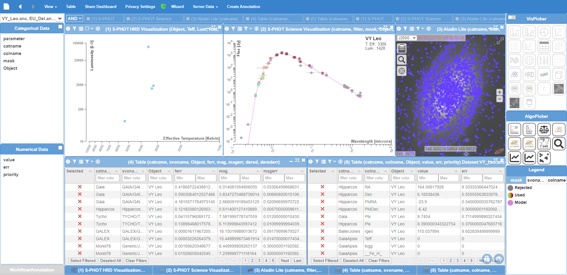
Create your own sky map, find the weirdest stars and explore the surface of the Moon with the EXPLORE astronomy toolkit
EXPLORE Project Press Release
A new set of tools for astronomers and planetary explorers use interactive visual analytics and machine learning to reveal and contrast properties of objects in our galaxy. From identifying the ‘weirdest’ outliers in a population of stars to creating maps of the dusty Milky Way, or combining datasets for an immersive exploration of the lunar surface, the open-source tools are designed to help astronomers investigate, annotate and work together on interesting results in a collaborative online environment.
The EXPLORE toolkit, which has been developed with funding from the European Commission’s Horizon 2020 programme, was presented last month at the Astronomical Data Analysis Software & Systems (ADASS) XXXIII conference and during a technology workshop at the Italian Space Agency’s headquarters.
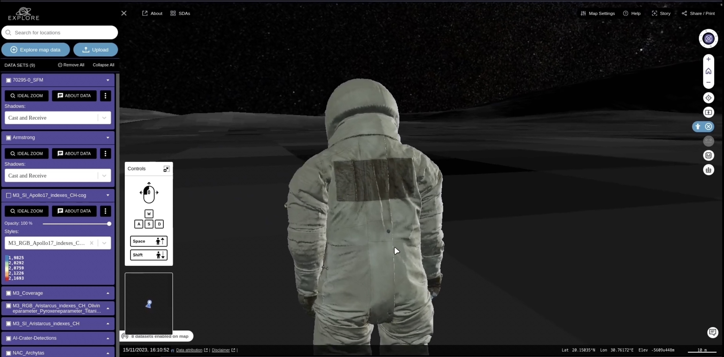
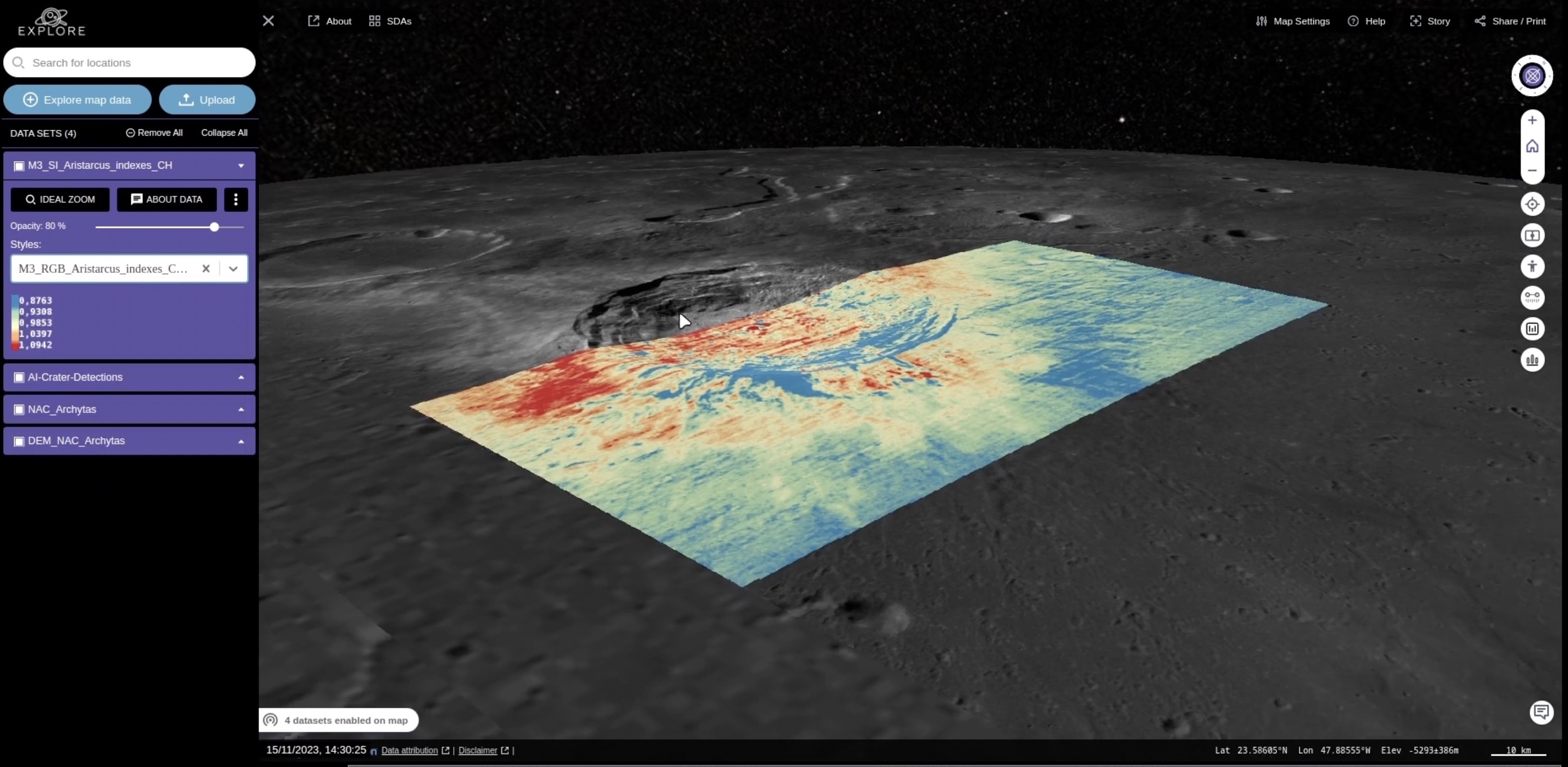
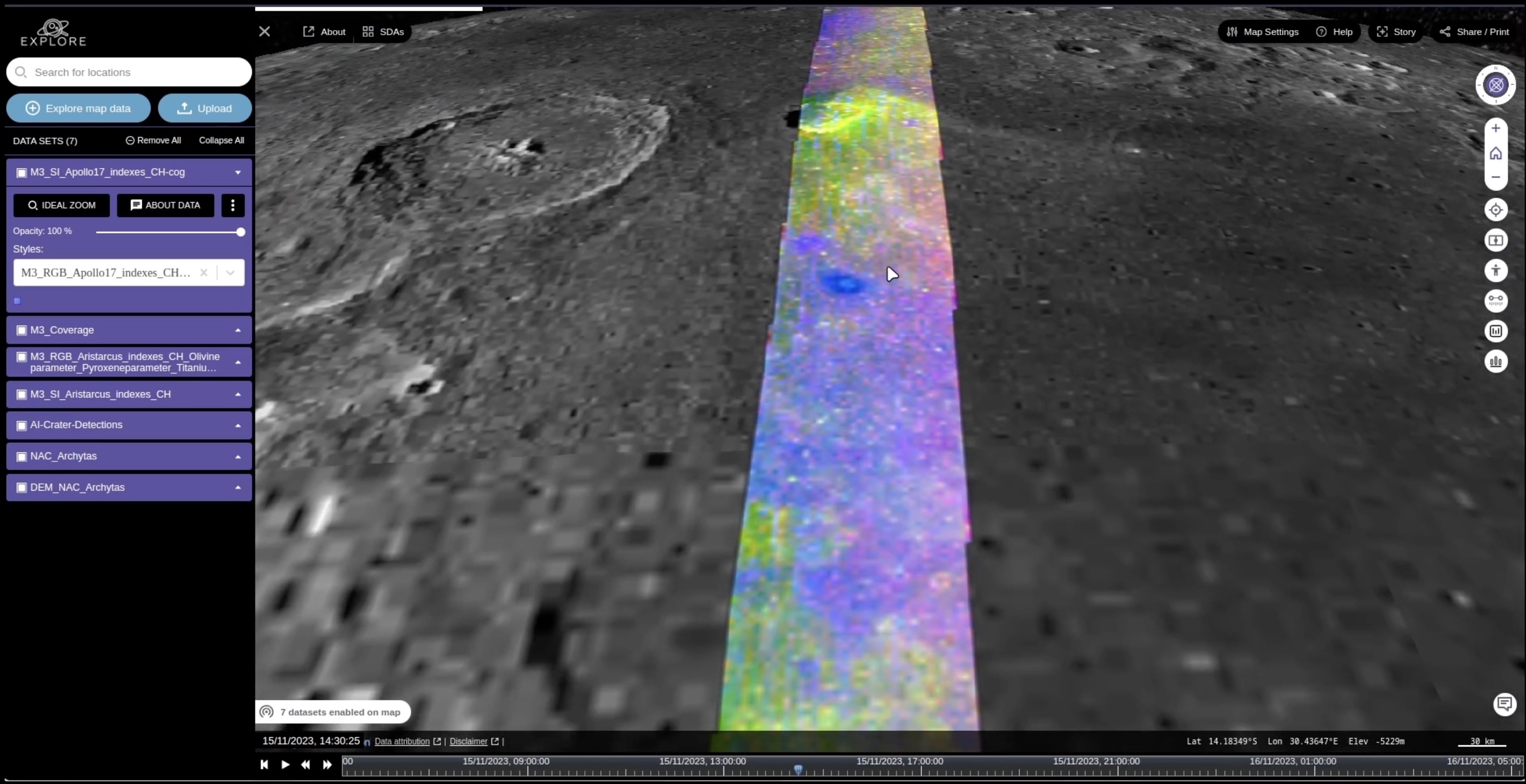
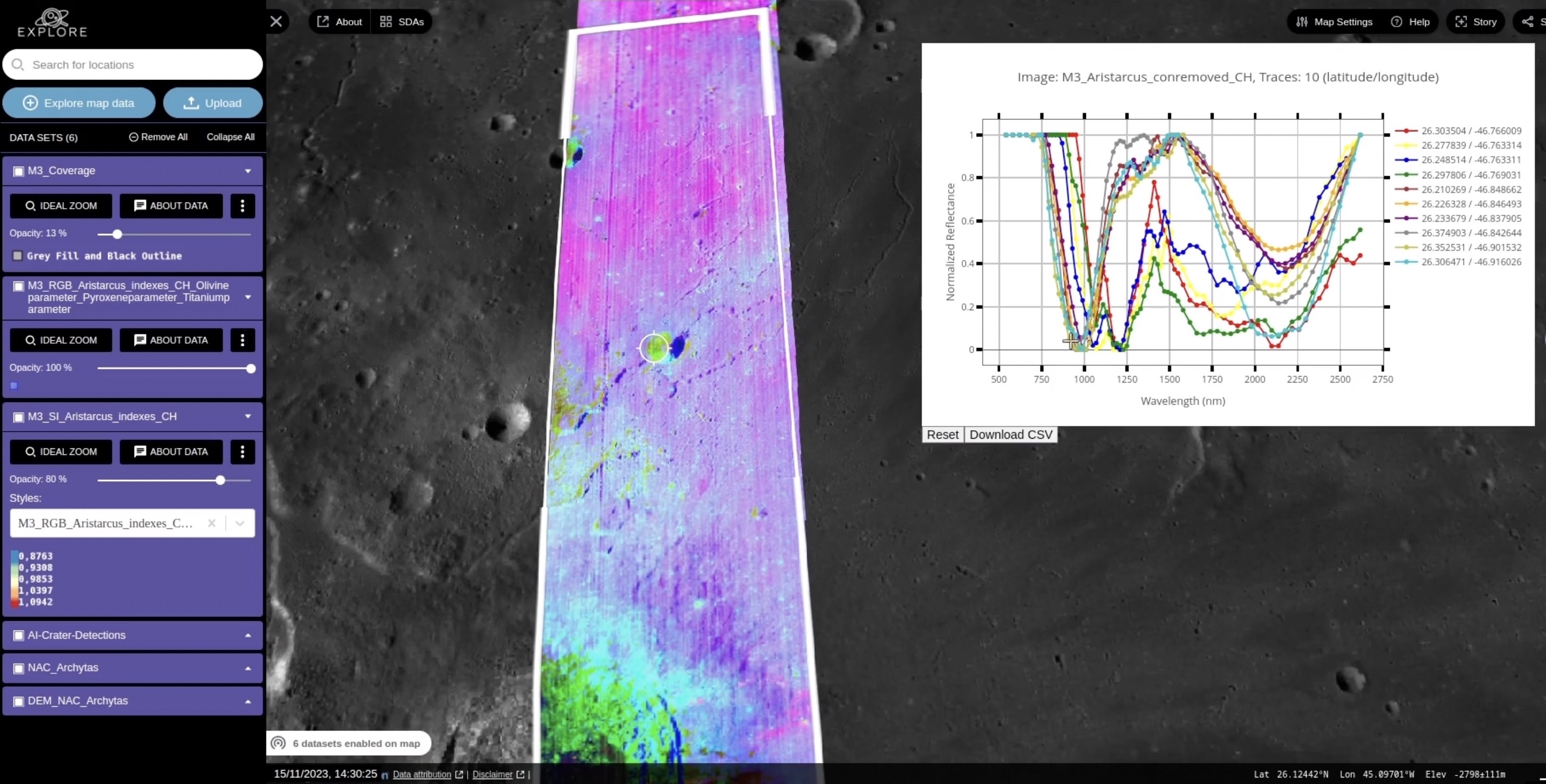
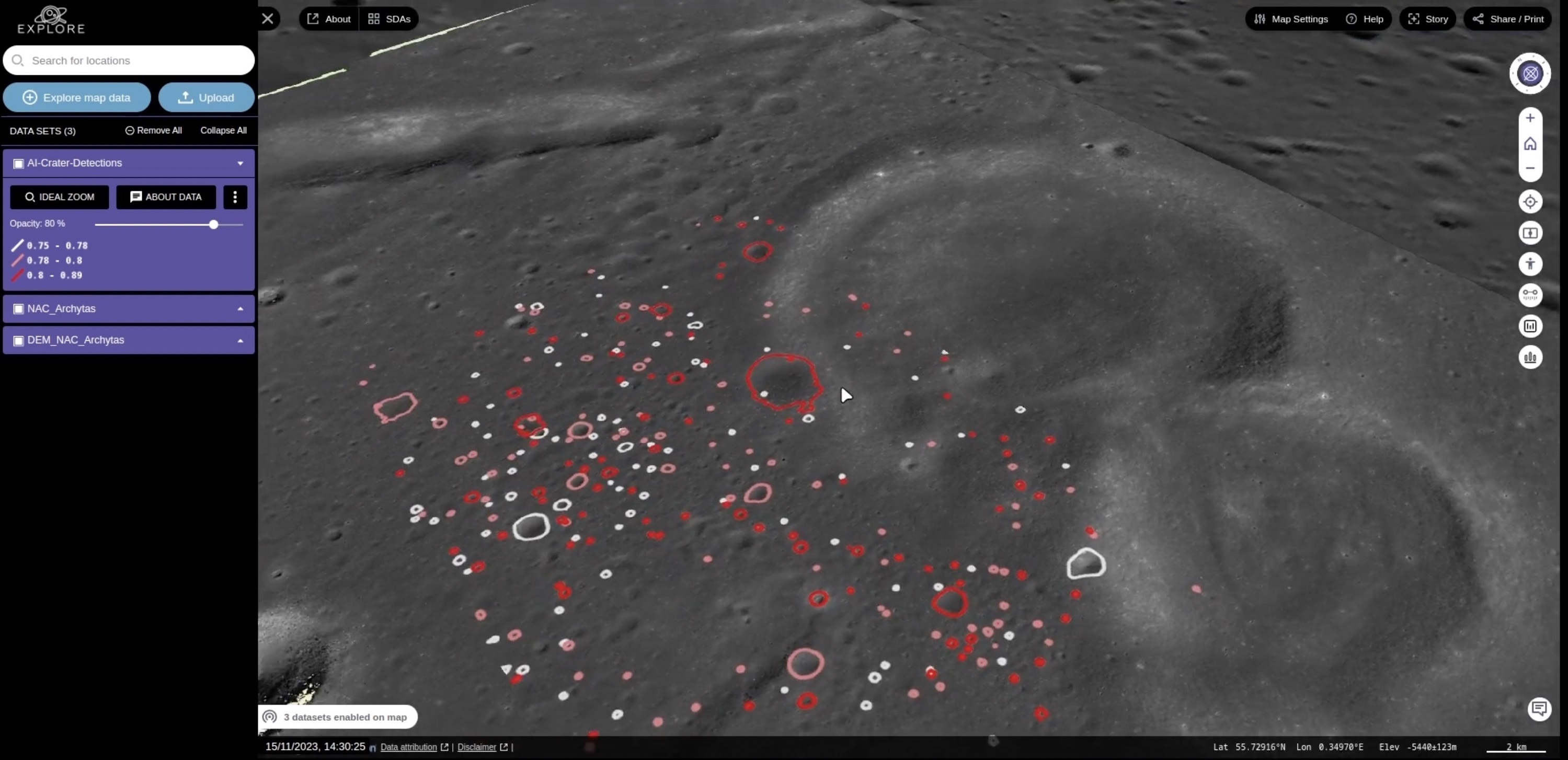
EXPLORE’s lunar tools allow users to navigate a 3D model of the Moon and upload, display and compare multiple datasets from lunar missions. Zooming in on a location, users can overlay basemaps with contours, visualisations at different wavelengths and spectral information on the mineralogy of the surface. Pre-trained deep learning models help identify craters and map features. A ‘pedestrian view’ enables users to visualise themselves standing and moving around the lunar surface through digital elevation models.
Tools for stellar research are designed to investigate the properties of stars in the Milky Way observed by theEuropean Space Agency’s Gaia mission and in other large databases. Assigning a weirdness score to spectral data can help astronomers find unusual stars, or groupings that have similar characteristics, within a population of a million stars. Comparisons of the brightness of stars at different wavelengths can reveal information on the temperature, age, size and amount of energy stars produce. When applied to a census of all the stars in the Milky Way, these collective results can help unravel the overall composition of our galaxy, and how it was built up.
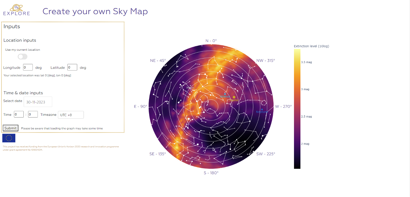
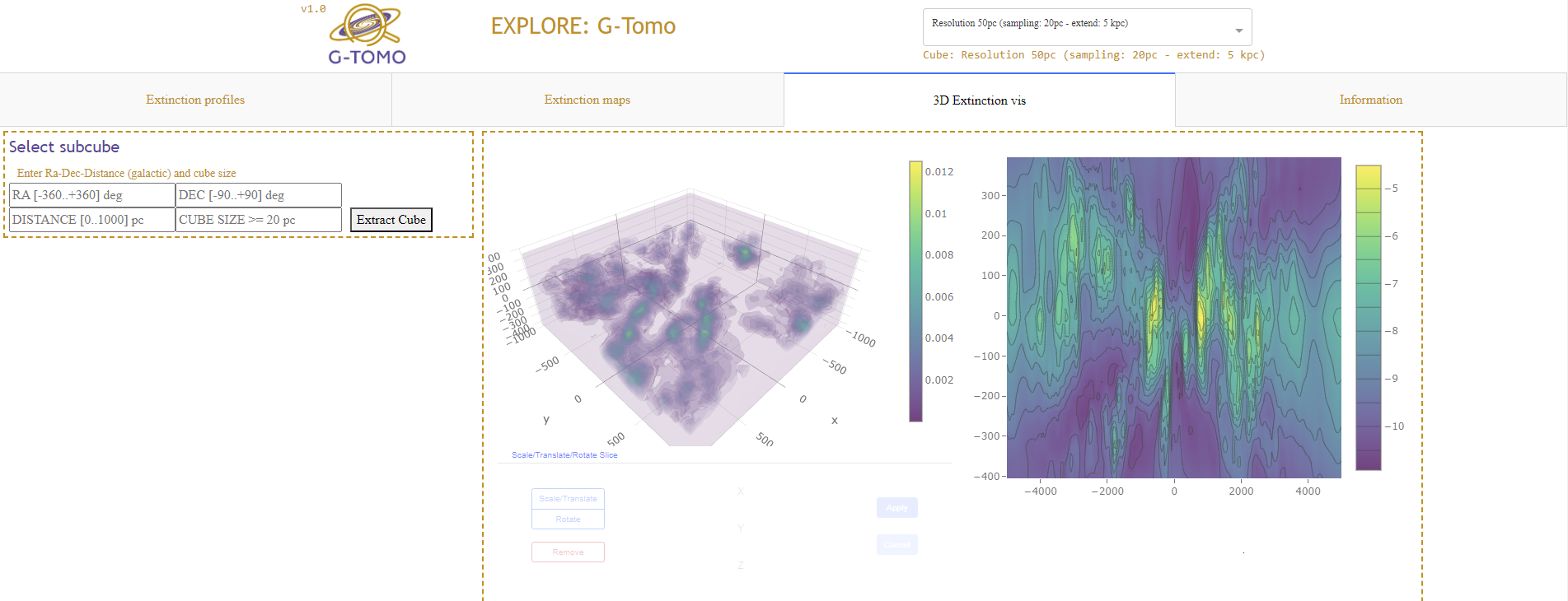
Galactic tools enable users to look at dusty objects and the distribution of dust in the Milky Way in one, two or three dimensions. Slicing through the galaxy in any orientation can reveal where dust is densely clumped and where there are windows that offer potential sightlines to objects of interest. Interactive sky maps show how the dust band at the core of the Milky Way passes overhead through the day and night at any given location on Earth.
Nick Cox, the coordinator of EXPLORE, said: “These EXPLORE science applications are demonstrators for astronomers working in a broad range of fields, including stellar spectroscopy, galactic archaeology and lunar exploration. Both the EXPLORE tools and the platform they are deployed on are very flexible and can be adapted to other areas of astronomy and planetary science.”
Manuela Rauch, of the Know Center, who led the development of the visualisation tools and user interface, said: “Our goal for EXPLORE is to supply methodologies, tools and inspiration for others to create their own web apps and services!”
Giacomo Nodjoumi, of Constructor University, who developed the lunar exploration tools, said: “These new tools for the scientific community are completely open source, modular, expandable and scalable, with no installation required.”
Animations
Sky map animation showing the concentration of dust in the Milky Way above the skies of Brussels through the day and night. Credit EXPLORE consortium. The star catalogue used for the constellations is copyright 2005-2020, Marc van der Sluys, hemel.waarnemen.com and used under (CC BY 4.0) licence.
The EXPLORE lunar tools include a ‘pedestrian view’ for visualising the exploration of the lunar surface. Credit: EXPLORE Consortium/TerriaJS/Smithsonian/NASA/GSFC/ASU/LROC Team/USGS.Using the EXPLORE lunar tools, basemaps of visible imagery of the lunar surface can be overlaid by spectral data that indicate the mineralogy rocks present. Credit: EXPLORE Consortium/TerriaJS/ISRO/NASA/JPL/GSFC/ASU/LROC Team/USGS.Using the EXPLORE lunar tools, basemaps of visible imagery of the lunar surface can be overlaid by observations in other wavelengths. Clicking on points can reveal the spectral profile and chemical make-up of the rocks present. Credit: EXPLORE Consortium/TerriaJS/ISRO/NASA/JPL/GSFC/ASU/LROC Team/USGS.Using the EXPLORE lunar tools, basemaps of visible imagery of the lunar surface can be overlaid by observations in other wavelengths. Clicking on points can reveal the spectral profile and chemical make-up of the rocks present. Credit: EXPLORE Consortium/TerriaJS/ISRO/NASA/JPL/GSFC/ASU/LROC Team/USGS.With the EXPLORE lunar tools, pre-trained deep learning models help identify craters and map features. Credit: EXPLORE Consortium/TerriaJS/NASA/GSFC/ASU/LROC Team/USGS.Screenshot of interface to create your own sky map showing the concentration of dust in the Milky Way overhead at your chosen location and time of day or night. Credit: EXPLORE consortium; the star catalogue used for the constellations is copyright 2005-2020, Marc van der Sluys, hemel.waarnemen.com and used under (CC BY 4.0) licence.Taking a slice through regions of the Milky Way shows where there are dense clumps of dust and potential sightlines to interesting objects. Credit: EXPLORE Consortium.The stellar tools reveal information on the temperature, age, size and amount of energy stars produce for a population of a million stars in the Milky Way. Credit: EXPLORE Consortium.
Science Contacts
Nick Cox Coordinator, EXPLORE Project ACRI-ST nick.cox@acri-st.fr
Manuela Rauch Know Center GmbH, Graz, Austria mrauch@know-center.at
Giacomo Nodjoumi Constructor University gnodjoumi@constructor.university
Innovative Scientific Data Exploration and Exploitation Applications for Space Sciences (EXPLORE) has received funding from the European Union’s Horizon 2020 research and innovation programme under grant agreement No 101004214. https://explore-platform.eu
The six scientific data applications developed by EXPLORE are:
Galactic:
G-Arch: Galactic Archaeology
G-Tomo: Interstellar 3D tomography of dust and gas in the Galaxy
Stellar:
S-Phot: Stars and their blue infrared colour excess: signs of activity and circumstellar material
S-Disco: Spectral discovery of stars
Lunar:
L-Explo: Global multi-scale compositional higher-level products for the lunar surface
L-Hex: Human lunar exploration landing site characterisation and support
Join the 2024 GMAP Geology and Planetary Mapping Winter School!
The GMAP Geology and Planetary Mapping Winter School is an exciting opportunity to delve into planetary geological mapping with guidance from experienced scientists. The Winter School is led by GMAP, Europlanet’s geological mapping activity.
Building upon earlier editions targeting Mars, the Moon, and Mercury, the 2024 Winter School will cover exemplary geologic mapping aspects on Venus, Icy Satellites and Small Bodies.
The Winter School will be largely hands-on, with the inclusion of seminars and time for asynchronous interaction and individual/project mapping work. Topics covered include: Basemap resources, QGIS project creation, and practical experience of map crafting.
The school will run synchronously in the week 22-26 January 2024, and asynchronously on the Streavent platform for the following month (February 2024). As usual, materials will be freely available after the school, for interested parties, to learn individually at their own pace.
Each body of interest will be introduced, hands-on activities will be described, and participants will be guided through the task, i.e. individual completion of a small mapping area. At the end of each day, specific time slots are dedicated to seminars, which will provide insights, perspectives and additional knowledge on related topics.
After the synchronous and asynchronous phases of the School, no dedicated support will be provided, but any interested party is welcome to participate to the monthly GMAP calls, as well as to join the GMAP Discord server for discussion and support.
Planetary geologic mapping and modelling winter school
The PLANMAP team, in collaboration with Europlanet 2024 RI’s GMAP initiative, announces the first PLANMAP winter school on planetary geologic mapping and 3D geological modelling, that will be held virtually 1-5 February 2021. The PLANMAP winter school will provide an overview of the technical and scientific skills needed by the next generation of planetary mappers.
The last 20 years of science exploration changed dramatically the technical and scientific skills required to perform planetary geological mapping, so that the required knowledge are continuously evolving. The Planetary geologic mapping and modelling winter school will address the most recent outcomes on the production of planetary cartography, providing the students with the basics needed for map creation, their use for scientific investigation, landing sites characterization, rover mobility and resource exploration.
Timeline
Important notice!
REGISTRATION ARE CLOSED
Due to the large interest in the winter school registration closed early. More calls will be opened in the future.
Europlanet 2024 RI has received funding from the European Union's Horizon 2020 research and innovation programme under grant agreement No 871149.
Europlanet AISBL (Association Internationale Sans But Lucratif - 0800.634.634) is hosted by the Department of Planetary Atmospheres of the Royal Belgian Institute for Space Aeronomy (BIRA-IASB), Avenue Circulaire 3, B-1180 Brussels, Belgium.