Report Summary: A total of 184 U-Pb-ages of zircon from eclogites from Sulu-Dabie UHP metamorphic belt (China), the D’Entrecasteaux Islands (Papua New Guinea) and the Western Gneiss Region (Norway) were successfully determined using the SHRIMP IIe/mc of the Korean Basic Science Institute.
Using the concordia method, we could identify a concordant age of the peak metamorphism of eclogite from Sulu-Dabie of ca. 240 Ma. In addition, a discordant age of around 720 Ma could be identified, which may reflect the age of inherited, magmatic zircon cores. The zircon from the D’Entrecasteaux Islands revealed ages below 8 Ma, which is younger than ages previously measured on the same sample in a previous study. This makes this sample one of the youngest eclogites ever discovered on Earth’s surface. Zircons from the Western Gneiss Region reveal ages of three distinct events. With 1.5 Ga, the oldest age determined probably reflects the Precambrian formation of the UHP region, while ages of around ca.
900 Ma correspond with the Sveconorwegian orogeny. The youngest age found in Norway reflects the Scandian orogeny at an age of ca. 415 Ma. The age information obtained will help us to develop improved evolutionary models for the formation of UHP rocks by combining these ages with trace element data.
Report Summary: This study investigates the Neoarchaean to Paleoproterozoic Transvaal Supergroup sedimentary sequence in Botswana that formed in the centre of the Kaapvaal Craton during the early oxygenation of the atmosphere. We used U-Pb dating on magmatic and sedimentary zircons from throughout the sedimentary sequence to determine the tectono-magmatic evolution of the hinterland basement. This approach constrains regional crustal growth, uplift and erosion events and establishes if additional cratons were in the hinterland, e.g. Pilbara. Knowledge of zircon provenance will allow critical comparison to known tectonic scenarios, e.g. Alpine style molasse basin and any potential change in Neoarchaean tectonics by considering erosion and crustal growth-reworking. The geochronology results help evaluate spatial and temporal variations in depositional environments associated with oxygenation of the atmosphere. Results indicate that the age of the basement, Gaborone Granite and the Kanye volcanic are indistinguishable (2768.9 ± 6.0 Ma). Sediments deposited from 2.642 Ga to 2.550 Ga are also dominated (> 90%) by zircons of ~2.77 Ga. This implies that there was a major crustal growth event in the Kanye region at 2.77 Ga that included minimal crustal reworking. Erosion products to the Kanye Basin are derived from this juvenile crust throughout the Archaean and Proterozoic until > 2.0 Ga. Only then are older and younger basement rocks recorded in the sedimentary sequence. This region of the planet yields no evidence of a major tectono-magmatic event associated with the oxygenation of the atmosphere.
22-EPN3-041: Study of the Dust Lifting Phenomena and Electrification Processes in a Martian Analogue Site
Visit by Gabriele Franzese (INAF-OACN, Italy) and Hezi Yizhaq (Ben-Gurion University of the Negev, Israel) to TA1.5 Makgadikgadi Salt Pans (Botswana). Dates of visit: 24 July – 02 August 2023
We performed a field campaign in the Makgadikgadi Salt Pans, during the dry season, to study the local dust lifting events and test a space designed dust sensor. With these purposes, we deployed a fully equipped meteorological station with the addition of a camera system and of the MicroMED sensor, the Optical Particle Counter selected on board of the ExoMars programme to characterise in situ the martian airborne dust. Here we used the terrestrial version of MicroMED, fully representative of its Martian counterpart.
We spent one week between two sites, facing different soil and wind conditions and successfully achieving both aspects of the campaign. MicroMED was indeed able to automatically operate using a preloaded acquisition schedule during day and night, in a range going from clear to highly loaded dust conditions. The campaign has hence been truly representative of the martian expected scenario and the data will be useful for further tuning the sensor and its functioning pipeline. Moreover, MicroMED acquisitions are precious also for studying the dust lifting events, in combination with all the other installed sensors. We were indeed able to monitor two days of intense dust devil activity, performing also an image survey of the events. The acquired data are promising, being under various aspects totally new to the literature. They can hence lead to highly improve our knowledge of the dust lifting phenomenon, regarding in particular the induced electric field
22-EPN3-026: Life detection and biosignature preservation studies via lipid biomarker analysis in Makgadikgadi Salt Pan
Visit by Pablo Finkel and Laura Sánchez García (Centro de Astrobiología (CAB), CSIC-INTA, Spain) to TA1.5 Makgadikgadi Salt Pans (Botswana). Dates of visit: 02-09 October 2023
In large evaporitic basins such as the Makgadikgadi Salt Pans in Botswana, a series of strategies that promote the long-term preservation of lipids take place in its immediate subsurface: protective mineral-organics interactions, halite encapsulations within matrices, salt-derived enzymatic inhibition, cellular adaptations, and entombment by chemical precipitation of minerals. These strategies, plus the high preservation potential of lipid biomarkers, crafts a recipe for optimism in regard to the state of the lipids found in Makgadikgadi, whose degradation may be effectively attenuated as their preservation is enhanced.
The main goal of this project was to collect different types of samples from the pans to characterise their lipid biomarker content to a) identify biological (molecular and isotopic) features and b) to assess lipid preservation and/or degradation. Samples with protective matrices suitable for organics preservation include halite crusts, xero-mineral matrix and silcretes from Sua Pan, as well as silcretes, calcretes and mineral precipitates found in inverted channels from a relict delta. More humid samples where these protective features may lack included surface and subsurface soil samples from concentric layered mounds believed to have formed under a water table. Nonethless, these mounds present a geomorphological analogy to the Equatorial Layered Deposits (ELD) on Mars, and given the infiltrating capillary fringe that render the Makgadikgadi mounds humid, a similar process on Mars could establish the ELDs as habitable refugia. In the laboratory, once the lipid profile of all samples is characterised, the team will proceed with irradiation studies to challenge lipid degradation in protective versus non-protective matrices.
Read the full scientific report with kind permission by Pablo Finkel and Laura Sánchez García.
22-EPN3-024: VIS-NIR and Raman measurement of clays and evaporitic products as analogs of Oxia Planum in the framework of the Rosalind Franklin rover mission
Visit by Marco Ferrari and Mauro Ciarniello (INAF-IAPS, Italy) to TA1.5 Makgadikgadi Salt Pans (Botswana). Dates of visit: 11-17 September 2023
This project aimed at a sampling campaign of evaporite and sedimentary products (e.g., sulfates, clays) and deposits showing evidence of biosignatures in the Makgadikgadi Salt Pans, Botswana. Samples taken from this location will be used for VIS-NIR and Raman spectroscopy measurements in the context of the future ExoMars mission.
To achieve this, the team visited 10 different sites in the Makgadikgadi Pan area, distributed across both the Ntwentwe Pan and Sue Pan during the visit. They collected 35 samples in different forms, both loose sediments with grain sizes varying from clays to sand, and cohesive sediments such as the salt crusts that characterise the top surface of the Pan. They also collected some solid rock blocks with sizes suitable for the laboratory setup of the Ma_MISS (Mars Multispectral Imager for Subsurface Studies) instrument (i.e. blocks with a maximum size of 10x10x10 cm), to perform drilling operations and spectroscopic measurements in the wall of the borehole.
The campaign aimed to confirm the ability of the Ma_MISS instrument to detect spectral signatures of organic substances in geological samples containing biosignatures. With the spectroscopic data obtained in the laboratory on the collected samples, the team aims to build a spectral database that will be useful to the scientific community.
These activities on terrestrial analogues have proven useful for understanding life in extreme conditions and how these can be preserved in the form of biosignatures and detected by the scientific instruments that will be on board future missions to Mars. In addition, this work will help to acquire crucial preparation for the exploitation and interpretation of the scientific data that the Ma_MISS instrument will provide during the active phase of the mission.
Read the full scientific report with kind permission by Marco Ferrari and Mauro Ciarniello.
20-EPN3-70: Investigation of geomorphic features in Ntwetwe pans, Makgadikgadi Basin, Botswana, using Ground Penetrating Radar: implications for Matrial surface landforms
Visit by Mebatseyon Shawel (Addis Ababa University, Ethiopia) to TA1.5 Makgadikgadi Salt Pans (Botswana). Dates of visit: 06-13 July 2023
The Makgadikgadi Basin in Botswana, covering an area of 16,000 square kilometres, is the largest salt pan in the world. Its formation is related to a tectonic episode in the Tertiary, possibly linked to the East African Rift System (EARS), which caused the subsidence and infilling with water and sediments. Changes in climate and tectonics eventually led to the drying up of the ancient lake, leaving behind the expansive salt pans we see today. The basin consists of two major pans, namely Sua and Ntwetwe, with a combined area of approximately 8,400 square kilometres. These pans are mostly flat but feature distinct geomorphic elements such as mounds and shoreline features that can be easily identified through satellite imagery. In the western part of the Ntwetwe pan, there are numerous mounds with an east-facing convex side and an average height of 5 metres. These mounds are primarily composed of fine-grained sands, calcareous sand, and occasionally contain bivalve shells. While several theories have been proposed regarding their origin, the internal sedimentary structure of these geomorphic features remains unknown.
On Mars, conical mounds are significant morphological features that have been observed and mapped in various regions. The Noachian-Hesperian climate change on Mars resulted in the deposition of crudely layered sediments in the equatorial region, where fluctuations in groundwater played a crucial role. These layered sediments, known as Equatorial Layered Deposits (ELDs), contain numerous mounds that were exposed due to impact craters. The objective of this study is to investigate the mounds in the Ntwetwe pan using geophysical methods, particularly Ground Penetrating Radar (GPR). By employing GPR, we aim to image the internal structure of these mounds and other geomorphic features, with the ultimate goal of understanding the formation and preservation of similar structures on the Martian surface.
Several sites within the Ntwetwe pan were selected for GPR survey, primarily along east-west and north-south profiles. These sites are located in the northwest, northeast, and central parts of the pan. Over a period of six days, approximately 23 kilometres of GPR data were collected. Most of the surveys utilized 50MHz antennas, while three lines were acquired using both 50MHz and 30MHz antennas to attain penetration depth as well as resolution. Preliminary results indicate clear imaging of the top 15 meters over the mounds and delta sites. However, reflections away from these structures appear to be weaker, possibly due to the high moisture content of clays on the pan floor, requiring further processing works to achieve better results.
22-EPN3-105: At the interface of ice and water on Mars – Insights from Western Greenland.
Visit by Anna Grau Galofre (CNRS/Laboratoire de Planétologie et Géosciences, France) and Axel Nobletto (Western University, Canada) to TA1.4 AU Greenland Kangerlussuaq Field Site (Greenland). Dates of visit: 25 July – 02 August 2023
Report Summary: The aim of this project was to investigate elements of the glacial and periglacial system surrounding Kangerlussaq, Western Greenland, to then compare them to similar landforms on the surface of Mars.
The first target in the field focused on investigating former subglacial drainage pathways that would have transported and accumulated water under the western Greenland ice sheet (GIS). Preliminary field observations, consisting of field and UAV imagery, mapping of former ice flow directions and sediment analyses, identified sets of bedrock incised depressions, linked by shallow channels that often cross drainage divides, point at a former subglacial drainage setting consisting of interlinked subglacial cavities. These observations would be consistent with present day radar observations of drainage pathways under the western GIS margin near Kangerlussuaq. Beside their interest for understanding the geometry of current subglacial drainage under Greenland, interlinked subglacial cavities are also interesting analogues to the martian so-called fresh shallow valleys, which are suggested to have formed under former ice cover.
The second field objective investigated polygonal terrain, its morphology, distribution, and the connection with the depth to the ice layer. We studied polygonised terrains around Kangerlussuaq, collecting image data, structure-from-motion, and depth to the ice layer. We also mapped the distribution of polygonal terrain as observed in the field and aerial imagery.
The results and interpretations will be applied to the study of Martian polygons, to propose a model of the buried ice conditions for Mars’ permafrost, and the development of channel systems.
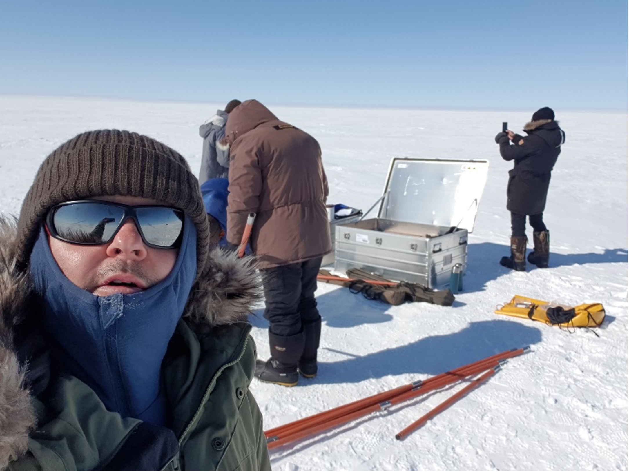
22-EPN3-049: Retrieving multiple ice cores covering the last 100 years to study the link between the solar cycle and the cosmogenic tritium in precipitation.
Visit by László Palcsu and Marjan Temovski (Institute for Nuclear Research, Hungary) to TA1.4 AU Greenland Kangerlussuaq Field Site (Greenland). Dates of visit: 19-23 June 2023
Report Summary:
The objective of the mission was to retrieve multiple ice cores at the EGRIP site (75°37′N, 35°59′W, 2702 m a.s.l.) to study the natural as well as anthropogenic variation of tritium in the ice layers. We have studied the recent publications, which suggest lower snow accumulation rate than what we have previously thought. Therefore, we intended to drill more shallow cores. During five days at EGRIP (19-23 June 2023), we drilled five 24 m-long ice cores representing the last 100-110 years. The ice cores were cut into subsamples of 15 cm, and packed into plastic containers. One full core was collected. The bottom part (depth between 16.2 and 24.0 m) of the additional 4 cores was also collected to get more material for sensitive analysis of tritium by the 3He-ingrowth method. Altogether 368 samples have been collected. Besides the cosmogenic tritium, stable isotopes of water, and Sr-Nd-Hf isotope signatures will be also analysed. To compare this latter to older ice (>10,000 years), we took ice samples at the ice margin in a location between the glaciers Isunnguata Sermia and Russell about 36 km from Kangerlussuaq, near Point 660. The ice there is supposed to be around 40,000 years old. We drilled a shallow core (~ 4 m), cut into 10 pieces, and stored in pre-cleaned plastic vessels. All of the ice samples have been already shipped to our laboratory in Hungary. The first analyses for stable isotopes, 137Cs around the Chernobyl event, and tritium around the bomb-peak have been already started.
Drilling down to 24 m in the clean area of the EGRIP site, Kangerlussuaq, Greenland. Credit: László Palcsu.
22-EPN3-126: In-Situ observations in support for VERITAS Venus analogue airborne radar campaign at Holuhraun and Djyngasandur, Iceland
Solmaz Adeli and Stephen Patrick Garland (German Aerospace Center (DLR), Germany) to TA1 – Iceland Field Sites, MATIS Dates of visit: 1-14 August 2023
The composition of lava fields on Venus and their alteration state is poorly understood. The Venus Emissivity Mapper (VEM)/VERITAS will observe the surface of Venus in the NIR range, which will allow studying the spectral characteristics of the Venusian surface, as well as the type of lava and likely alteration processes. To prepare for this mission, VERITAS organised a field campaign in Iceland in early August, 2023, which included in-situ NIR data acquisition by the DLR-Berlin team, enabled through this Europlanet funding. The main goals have been 1) to understand the in-situ NIR reflectance spectral response of Venus analogue material, 2) to acquire in-situ emittance of an active volcano in the NIR spectral range, 3) to collect samples to be analysed in the Planetary Spectroscopy Laboratory (PSL-DLR-Berlin) using reflectance and emittance spectroscopy methods, to create an emissivity spectral library, and 4) to compare the laboratory data with field measurements.
In order to collect a wide range of textures (from pahoehoe to a’a) and compositional variations of basaltic lava fields, in addition to different fumarolic deposits, the team visited and imaged the Holuhraun lava field, Askja lava field, and Fagradalsfjall area. These sites offer an age range from the altered 1960 Askja lava field to the 2023 eruption in Fagradalsfjall. The Askja and Holuhraun sites also offered variation in grain sizes and tefra and sand coverage, which affects the spectral behavior of the surface material in NIR. the team also collected about 60 kg of samples to be analysed in the Venus chamber of the PSL-DLR-Berlin.
Photos from the campaign can be found in the DLR Flickr Album: VERITAS – Expedition for NASA & ESA Missions to Venus:
22-EPN3-129: In-situ and laboratory spectroscopic characterisation of Icelandic lava flows; an analogue of Venus – VERITAS mission preparation
Nils Mueller and Akin Domac (German Aerospace Center (DLR), Germany) to TA1 – Iceland Field Sites, MATIS Dates of visit: 1-7 August 2023
As part of collaborative field work of the VERITAS science team, Nils Mueller and Akin Domac visited several locations with partially sediment covered lava flows in the vicinity of Askja, Vatnajokull National Park, Iceland. This was done simultaneously with an airborne radar campaign by the German Aerospace Center {DLR. e.V.) acquiring synthetic aperture radar images at X- and S-band, the wavelengths of the radar instruments on the Venus orbiters VERITAS and Magellan, respectively. The objective of the fieldwork was to document the nature and extend of sediment cover on lava flows and how it affects scattering and roughness at radar wavelengths. This will improve the combined Magellan/VERITAS SAR image interpretation by providing in-situ data that can be tied to specific S and X band backscatter values. Another aspect is change detection as the same airborne radar collected data of the near pristine Holuhraun lava flow in 2015.
The field work data collected includes photos, notes, LIDAR scans of SxS m2 patches, and clast and sediment samples from the the surface and, if possible, from 20 cm depth. The initial observations show that parts of the Holuhraun lava flow have been significantly modified by aeolian sediments in the 8 years since the end of the eruption. These sediments affect the roughness on radar wavelengths but also radar backscatter via changes in composition, density, clast size, and water content. Whether the changes are notable in the radar images remains to be seen, as the interpretation is ongoing.
Photos from the campaign can be found in the DLR Flickr Album: VERITAS – Expedition for NASA & ESA Missions to Venus:
This project was designed to improve the understanding of biosignatures in analogue terrestrial surfaces, volcanic rocks, that result as a consequence of microbial colonisation and weathering. During the visit, the automatic medium-volume sampling system PNS DM — modified to run on batteries charged with solar panels — was assembled, tested, and calibrated in the laboratory of Matis.
Due to a delay in shipment of the solar panels, the installation of the system at the field site could not be performed but will be finalised by the host institution in the near future. As a part of the visit, the area of the Fagradalsfjall volcano was visited and the location where the sampling system will be installed was discussed. Once the sampler system will be installed in proximity of the Fagradalsfjall volcano crater, aerosol samples will be collected continuously for a year along with replicate rock samples in order to investigate the impact of aerosol deposition on rock microbial community assembly, using microbial, chemical and physical analysis. This will be performed in collaboration between the team of Prof. Viggó Þór Marteinsson and the team of Assoc. Prof. Tina Santl-Temkiv and will result in greatly improved understanding of colonisation, community assembly, and biosignature emergence in analogue terrestrial surfaces.
22-EPN3-007: SeisChem – The influence of seismic events on fluid and gas chemistry at the Icelandic planetary field site
Visit by John Edgar and Jon Telling (Newcastle University, UK) to TA1 – Iceland Field Sites, MATIS Dates of visit: 12-21 September 2023
Measurable H2 can be generated during active seismicity through the reaction of water with freshly created rock surfaces. Field measurements have shown that rock-water reactions during seismic events can also lead to significant changes in the pH and increase the concentration of H2O2 in geological fluids. Whilst prior studies have investigated locations representing felsic crust, a large proportion of the deep biosphere resides in basaltic terrains. H2O2 generated through rock-water reactions is greater in basaltic rocks and enhanced when temperatures exceed ~80 °C. Importantly, these elevated temperatures overlap the growth ranges of some hyperthermophilic microorganisms. The generation of H2O2 in these environments represents an understudied energetic window of opportunity for extant microbial life, and possibly for the origins of life on Earth.
This project sampled a seismically active hydrothermal area in Iceland where elevated temperatures were anticipated to lead to enhanced H2O2 generation from rock-water reactions. The SeisChem team investigated the relationship between seismicity and the products of rock – water reactions in a geologically active hydrothermal system. The central objective of SeisChem was to bridge a knowledge gap between laboratory studies and field measurements by:
Sample fluid and gas in time series, recording in-situ H2O2 and ancillary geochemical data
Store and return samples to the laboratory for H2 (g) and major ion (aq) analyses
Compare and contrast field and laboratory data with local seismic activity.
22-EPN3-130: Biosignatures in Icelandic geothermal aerosols
Visit by Mark Fox-Powell and Ben Stephens (Open University, UK) to TA1 – Iceland Field Sites, MATIS Dates of visit: 23-31 August 2023
The aim of our project was to capture and study microscopic aerosols ejected from bubbling geothermal springs in Iceland, as an analogue for the formation of cryovolcanic plumes at icy moons such as Enceladus. This project built on a successful Europlanet-funded field campaign in 2022. Our objectives in 2023 were to (i) comprehensively map size-dependent aerosol fluxes with increasing distance and elevation from the springs; and (ii) to collect simultaneous samples for microbiological and elemental analyses at multiple downwind locations.
We focused our investigations on Olkelduhals hot springs, near Hverageroi, where a pool with circum-neutral pH supporting thick microbial streamers experiences constant moderate gas flux. Our data from 2022 showed that this spring is a prolific and constant source of aerosols. We found that downwind aerosol size distributions changed with distance and with elevation from the spring. Four complete aerosol sample sets were taken downwind of the spring; each requiring a full field day. A background (upwind) air sample was also taken. Comprehensive samples for geochemical and microbiological analyses were taken from the spring, along with the collection of volatile and semi-volatile organic compounds using thermal desorption tubes. The sample set will form the basis of a new PhD studentship, beginning in October 2023 at the Open University, which will investigate the chemical composition, biomass content and microbial diversity of aerosols, and the volatile profiles of geothermal gases. Our data will provide the first insights from natural analogues into the formation of aerosols within cryovolcanic plumes.
Visit by Işık Su Yazıcı (German Aerospace Center DLR, Germany) and Sebastian Sturm (University of Freiburg, Germany) to TA1 – Iceland Field Sites, MATIS Dates of visit: 02-10 August 2023
Fault population studies reveal the lithospheric stress and strength conditions. Geometric fault properties provide insights into mechanical and temporal evolution of fault systems, as well as past and future potential for seismic energy release. Understanding the displacement-length relationship of faults can also help to estimate the current seismicity level. Improved constraints on the current seismicity of Mars based on lnSight mission results, are the motivation for a renewed and detailed analysis of martian fault systems. Partly due to the limited number of reliable datasets, data on the relationships between fault displacement and length of extraterrestrial bodies are scarce. Using Digital Elevation Models (OEM) and corresponding orthoimages derived from High Resolution Stereo Camera (HRSC) data, we previously obtained information on the displacement distribution along faults and the maximum displacement (Dmax) at the Memnonia Fossae (MF) fault system on Mars.
The volcanic rifting zone in SW Iceland displays similar characteristics as MF. Specifically, the availability of airborne HRSC data (HRSC-AX) of an area characterized by widespread normal faults in the rift zone at Thingvellir, and well-exposed faults in Reykjanes, are exceptionally well-suited sites as analogues for the MF. Considering the scarcity of terrestrial analogue work complementing the analysis of planetary fault scaling, this field work helps to improve our understanding of fault scaling relationships: Our goal is to combine terrestrial remote sensing data (HRSC-AX) with ground truth to obtain a better basis for evaluating planetary fault scaling (which relies on remote sensing only).
22-EPN3-061: Analogue Studies to Test the Scientific Potential of the First SERS Prototype Analysis
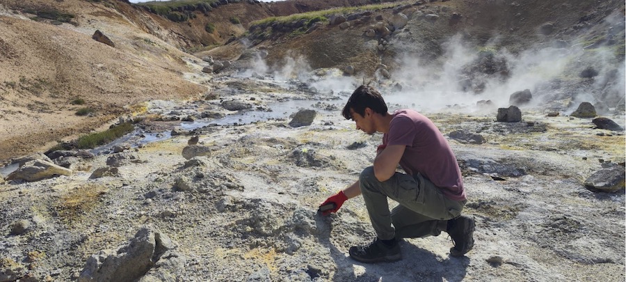
Marco Veneranda and Guillermo Lopez-Reyes (University of Valladolid, Spain) to TA1 – Iceland Field Sites, MATIS Dates of visit: 24-30 July 2023
Iceland provides access to a great variety of environments that are widely considered potential analogues of hydrothermal processes on Mars). Previous investigation revealed a wide variety of microbial communities proliferating at the water side of Krysuvik and Hveradalir hydrothermal systems. Although providing crucial information on the dynamics of extremophilic life, the lack of low altered mineralogical samples prevented from: 1) fully comprehend the hydrothermal weathering dynamics of the primary rock (extrusive Fe-rich basaltic lava), and 2) determine the relation between microbial proliferation and the degree of hydrothermal alteration of the hosting mineral substrate.
As these two aspects are of key importance to understand the habitability potential of the ancient hydrothermal systems found on Mars, Marco Veneranda and Guillermo Lopez Reyes performed a new campaign of analysis to address these two topics. On one hand, the two researchers investigated the mineralogical composition of the two analogue sites by using a portable emulator of the RLS Raman spectrometer onboard the ESA/ExoMars rover. Afterwards, a novel device for the automated synthesis of SERS nanoemulsions was used to investigate the organic content of the hydrothermal waters. The obtained results were then used to select optimal geological and biological samples to be returned in the laboratory for further investigation. As a whole, this research project aims at supporting the RLS team in defining and optimizing the potential scientific outcome of the RLS instrument once it will be operated on the surface of Mars.
Read the full scientific report with kind permission by Marco Veneranda and Guillermo Lopez-Reyes.
Molecular analysis performed in-situ by using a portable Raman spectrometer at the hydrothermal areas of Krýsuvik and Hveradalir. Credit: M Veneranda.
22-EPN3-011: Phototrophic Microorganisms in Cold Deserts of Iceland – Ecology and Diversity of Potential Analogues
Visit by Daniel Remias (University of Salzburg, Austria) and Lenka Procházková (Charles University, Czech Republic) to TA1 – Iceland Field Sites, MATIS Dates of visit: 07-13 July 2023
Geology and climate of inland regions at Iceland are ideal prerequisites for exploring microbial adaptation to cold and dry habitats. Bare terrestrial ground surfaces and highaltitude melting snowfields represent niches at the edge of life on Earth. Soil samples were harvested at altitudes from almost at sea level up to more than 1000 m. Additionally, red snow caused by cryoflora (snow algae) from permanent snow packs in the Kerlingarfjoll Mountains were collected, and photosynthetic uptake rates were measured in situ with labelled carbon (13C). Red snow was transported to the lab and the pigments extracted and the UV-protecting pigments characterized by HPLC.
The main aim of the project was the molecular characterisation of the phototrophic microbial community for evaluation of abundance and diversity of terrestrial and frozen habitats. Barren, desertlike sites were compared with vegetated ones. Microalgae marker DNA were extracted with dedicated kits for environmental soil samples.
This study aims to shed light on how photoautotrophic microbial life could work at Earth analogues with similar or even worse climatical or soil conditions. Finally, Icelandic terrestrial microalgae will be tested as potential analogues compared to other worlds like Mars or icy moons.
Read the full scientific report with kind permission by Daniel Remias and Lenka Procházková.
Image credit: Desert-like sampling site close to Sandfell Mt. Credit: D Remias.
Report summary: The electrical charge carried by volcanic ash particles is known to play a crucial role in the formation of aggregates, which modulate the atmospheric transport and deposition rate of volcanic ash. However, direct field measurements of these charges remain rare, and more investigations are required to better comprehend both charge generation and aggregation mechanisms. This study aimed at building and testing a portable device to quantify the charge of individual volcanic ash particles and aggregates using a Through-Type Faraday Cage (TTFC) connected to a charge amplifier circuit capable of detecting the very small voltages induced by charged particles entering the TTFC.
After building the apparatus, 187 tests were performed, using different quantities and types of particles, as well as varying the measurement technique. First results show that the newly built device is capable of measuring charges down to 0.1 pC and that measurements agree well with alternative estimations obtained by directly integrating the current generated in the TTFC over time.
Beside the charge, results also suggest that the device can be used to obtain the particle settling velocity, based on the duration of the voltage signal. Few additionnal tests are now required to detect smaller particles (i.e., smaller charges) and the instrument will then be used for field analysis and laboratory experiments.
Report summary: The main goal of most recent tests conducted at the Planetary Environment Facilities at Aarhus University was to condense CO2 from the chamber’s atmosphere under Martian conditions onto a specially designed set of different surface materials (martian regolith simulant, glass beads of various sizes, dust). We investigated ranges of temperatures and pressures and observed the texture of the created CO2 ice. Our goal was to determine if CO2 deposits over regolith/glass beads/dust differently compared to brushed aluminium. We have observed that various properties of substrate did not considerably alter the deposition morphologies of CO2 observed in our previous work. Most importantly, we find that under conditions usual for Martian polar areas in fall and winter, CO2 ice always deposits as a translucent slab. Under deviating conditions, i.e. colder temperatures and lower pressures, CO2crystals assume different shapes including opaque slab and highly porous multi-crystalline. Such CO2crystalline morphologies require further investigations, because of their relevance to icy satellite surfaces as well as CO2 cloud formation.
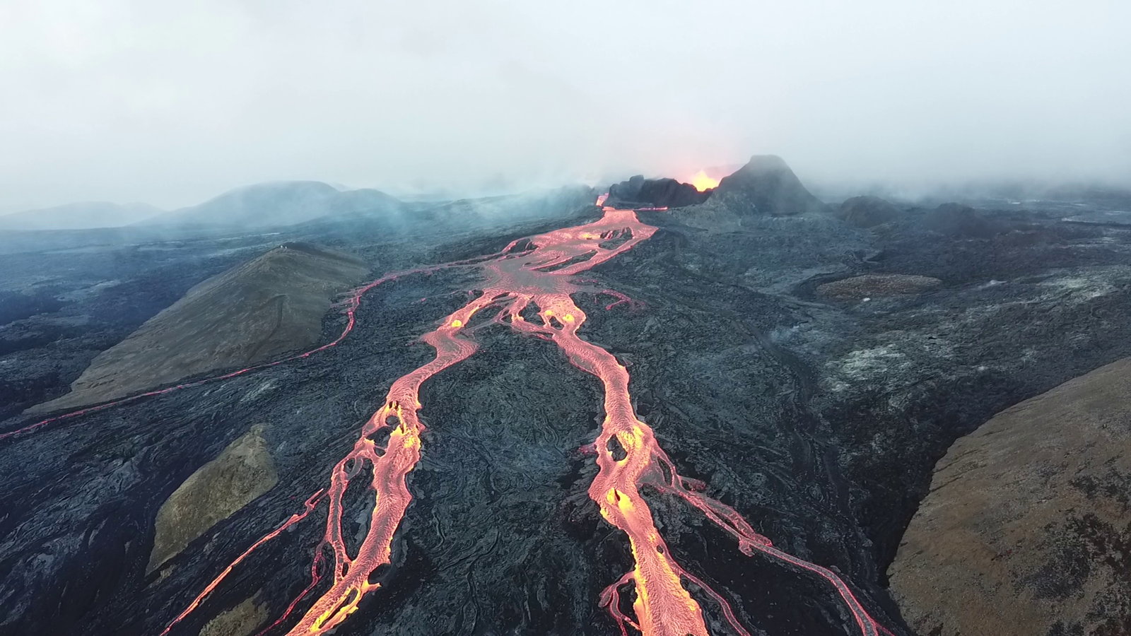
Solmaz Adeli and Nils Müller are travelling to Iceland this summer to carry out two research projects in support of upcoming missions to Venus. Their visit, from 31 July – 14 August, is partly funded through Europlanet’s Transnational Access programme and the trip is part of a larger, international campaign organised by NASA‘s Jet Propulsion Laboratory (JPL) and the German Aerospace Centre, DLR.
Volcanic field sites in Iceland can be used as planetary analogues for Venus, since their resemblance to terrains and environments on Venus enable a better understanding of the processes that shape the venusian surface, and also provide an opportunity to test out instrumentation.
Iceland’s Fagradalsfjall volcano erupting in 2021. Credit: CC BY-SA 4.0 Mokslo Sriuba
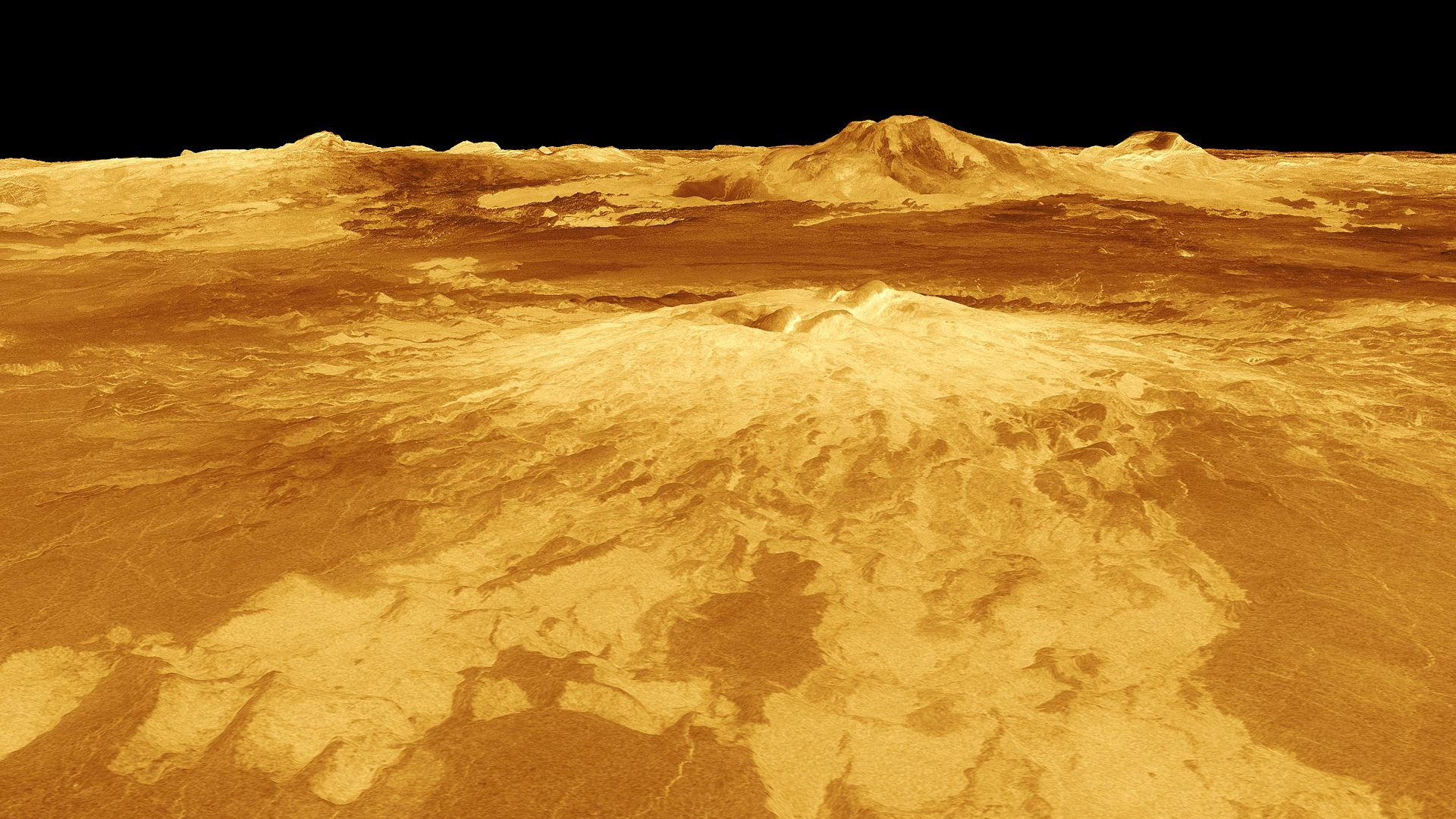
3-D perspective view of Sapas Mons on Venus, with lava flows in the foreground. Credit: NASA/JPL
Solmaz, of the DLR Institute of Planetary Research, is leading a project that uses field sites on Iceland to help characterise the composition and origin of the major geologic terrains on the venusian surface, one of the main objectives of the NASA VERITAS and ESA EnVision missions. Her team will use a prototype of the VEM instrument, which will fly on-board VERITAS, to characterise lava flows in the Reykjanes peninsula, which range from very fresh terrains to areas that have been altered over time. “Very fresh” in this case even means that, by coincidence, the team will be able to measure hot lava that is currently erupting from the active Fagradalsfjall volcano since 10 July this year. The red-glowing lava rocks of the Litli-Hrútur eruption cone have about the same temperature as the surface of Venus, which is a 470 degree Celsius hothouse day and night. The team will also collect samples and take them back to the PSL laboratories at DLR-Berlin for analysis in the Venus emissivity chamber.
This project will increase our understanding of the spectral emissivity data that will be obtained by the VERITAS and EnVision missions, and be an opportunity to calibrate field data taken by the prototype VEM instrument
Nils, a postoc at the Freie Universität Berlin, is leading a project to better understand volcanic activity on Venus by investigating the infrared signal of active eruptions and searching for new lava flows. The Dyngjusandur sand sheet (a cold sand desert) and the fissure-fed lava flows, Holuhraun and Thorvaldshraun, are excellent analogues on Iceland to prepare for these studies because these recent lava flows at the sites are sufficiently large and intense to be detectable on Venus.
An issue that complicates the quantitative study of volcanic activity on Venus is the unexpectedly low reflected radar signal from Venusian lava flows, which suggests that detection of active flows may be difficult because they might quickly form uninterrupted crusts, obscuring the hot lava. It is, however, possible that wind-bourne sediments are partly responsible for these low radar reflections. The Iceland volcanic sites are very well-suited to study how sediments modify the radar signal of lava flows, so the study may give new insights into radar data collected at Venus.
The team aims to acquire airborne radar data, similar to the VERITAS radar data, and carry out field work simultaneously with the flight campaign. This ‘ground-truth’ data will include information on sediment coverage and humidity, which will help to interpret and add value to the radar data.
Uli Koehler, from the DLR Institute of Planetary Research, will be travelling with the expedition team and reporting on the campaign. For updates on their progress, see the DLR blog and follow the social media channels of DLR:
21-EPN-FT1-012: Zebra dolomites revised: clumped isotope analysis as a tool to assess recrystallisation and dolomite cementation in overpressured settings
Report Summary: Zebra dolomites are marked by an alternation of millimeter thick dark colored, as recrystallised interpreted bands and white cement bands. Disruption of the banding is manifested by displacements that gradually increases and subsequently deceases before disappearing. This disruption also occurs at intracrystalline scale with crystal rehealing features as observable under cathodoluminescence. This disruption of the zebra dolomites is explained by dolomitization in relation to overpressured fluid flow.
In the framework of the Europlanet project zebra dolomite samples from 3 deep Belgian boreholes (Soumagne, Soiron and Bolland) were selected for clumped isotope analysis. The aim was to sample and analyse the dark fine crystalline and white coarse dolomite cements separately to infer the original (re)crystallization temperature. The following research questions were raised: i) is there a systematic difference in deduced temperature between the dark and white dolomite bands. If so then this could help to better constrain the recrystallisation and cementation. This would allow to assess the potential resetting of the original clumped isotope signature of the dark bands due to recrystallisation; ii) if the cement phases display uniform temperatures then this temperature can be compared with the minimum crystallization temperature deduced from primary fluid inclusion microthermometry [1]. The discrepancy between both temperatures, which links to the pressure correction, normally allows to quantify the overpressure of the system; iii) based on deduced crystallization temperature and δ18OPDB, the δ18OSMOW of the fluid can be assessed, allowing to constrain the origin of the dolomitizing fluids, certainly when combined with Sr isotope analysis.
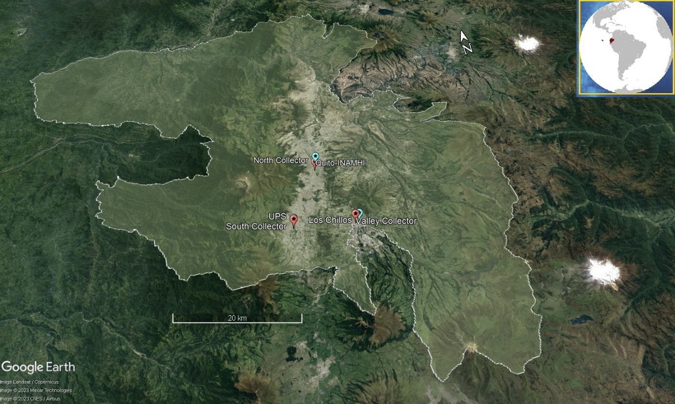
Report Summary: The goal of the 2023 visit to the TA Facility was to measure rainwater δ2H and δ18O values sampled at daily and monthly resolution from October 2022 to May 2023 in three different monitoring sites at North, South and Valley sites in Quito-Ecuador. Due to the complex orography, the sites experience varying intensities of rainfall and hailstorms. These measurements are part of a project aiming to understand the dynamical processes that contribute to the observed heavy and extreme precipitation events in the Tropical Andes, specifically in Quito.
Location of the installed rainfall collectors (red) and nearby meteorological REMMAQ stations (cyan). The borders of the city of Quito are marked by the white line. Credit: S Serrano-Vincenti.
Understanding these isotopic data will help the interpretation of the variations in δ2H and δ18O during intense rainfall events and subsequent fractionation due to local and upstream convection, orographic lift and moisture recycling. In addition to the measured isotopic signals, rainfall amount, pH, conductivity, and Total Dissolved Solids (TDS) data will be statistically analysed from the sites. Similarly, instrumental daily precipitation and cloud coverage information from instrumental and satellite data will be examined for convective rainfall (thunderstorms) and moisture provenance characterisation.
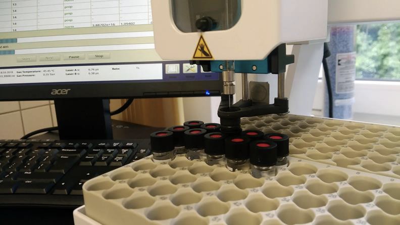
The Los Gatos spectrometer at the ISIL Credit: S Serrano-Vincenti.
Europlanet 2024 RI has received funding from the European Union's Horizon 2020 research and innovation programme under grant agreement No 871149.
Europlanet AISBL (Association Internationale Sans But Lucratif - 0800.634.634) is hosted by the Department of Planetary Atmospheres of the Royal Belgian Institute for Space Aeronomy (BIRA-IASB), Avenue Circulaire 3, B-1180 Brussels, Belgium.